- Supporting Manufacturing
Case Study of Powder and Multiphase Flow Simulation Software, iGRAF
AJINOMOTO CO., INC.
It was an article in the newspaper that attracted me to GPS and GNSS. The article said that the Japanese government and electronics companies were beginning research on a GPS for landing control systems of airplanes. In 1998, I joined an electronics company's aviation systems department that deals with radio waves and was involved in research on GPS/GNSS. During that time, all of the colleagues who were my age had an interest in that field of research. Personally, I wanted to devote myself further to the research, which is why I joined this university in 2001. Looking back at my business and academic careers, I have dedicated myself to research on GNSS for 17 years.
Yes. Around 2005, the University of Tokyo used the ray tracing theory to calculate the path of radio waves, and conducted a visualization simulation of satellites over the Ginza area of Tokyo. Under the assumption that any system to be used would be similar to the European GNSS, GALILEO (EU global satellite system), they calculated the number of satellites that would be "visible", or in other words, how many satellites would be useful.
Immediately I felt that it would be interesting to give it a try and I also wanted to take on the challenge of running simulations using a GNSS. But to create a ray tracing theory program in our research lab would consume too much time and labor. Our research lab's main issue was navigation positioning and not radio waves. Even if we succeeded in developing such a program, my students would have difficulties maintaining the program afterwards. When we were trying to search for a tool that we could use, we came upon KKE's RapLab. RapLab is a radio propagation analysis tool that also uses ray tracing theory. We didn't particularly have any confidence that it would go smoothly from the start, but when we tried it, we found out that it worked considerably well. Later, I found out that I had been the first to use RapLab for GNSS.
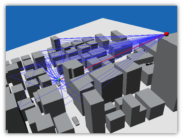
▲ Simulation image of "RapLab", a radio propagation analysis tool
We built a virtual city and satellites in RapLab and simulated the strength of the radio waves from a satellite to the city, and compared the results with actual data of radio waves from the satellite using measurements by driving a car in the actual city. The strength of radio waves fluctuates widely when blocked by tall buildings. With regards to that, RapLab simulation results were surprisingly close to the measured values, more so than I had expected, which convinced me to continue my research in this direction.
Using artificial satellites, GNSS is able to locate the positions of humans and objects on the Earth. Normally, it takes four or more satellites to discover one's (receiver's) position, based on the radio waves sent out from each satellite and the calculation of the time and distance for each of these signals to be "captured" by the receiver.
Presently the usage of GNSS is very diverse, ranging from car navigation to built-in GPS in smartphones, and even to navigation support for airplanes and vessels. Highly precise GNSS receivers are not only able to precisely perform horizontal measurements, but also elevation measurements, and because of that, GNSS can also be used in applications that require surveying or inclination measurements.
However, there is a weak point in some cases, and this is positioning errors. When the signal travels from the satellite, before it reaches the ground there are delays caused by the ionosphere and troposphere, and there might also be obstructions that affect it, depending on the receiver's surrounding environment. A city filled with tall buildings would be especially problematic, since the radio waves would reflect or diffract off of those buildings, causing delays in the calculation of time and distance between the satellite and the receiver. This is called "multipath propagation". As a result, there will be a misalignment of one's position. These signals can be completely out of range in some places that are blocked by buildings.
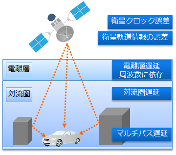
▲ Factors that affect GNSS measurements
Yes, which is why it is important to have area-specific signal strength data. Because the number of satellites in space and the angle that you see them from the Earth changes every day, with every minute and every second, obtaining time-specific data is also important.
To obtain such data, measurement is the quickest way. And if it were to be used in ITS (Intelligent Transport Systems) such as car navigation, it would be better to just travel from place A to place B and measure that data. Actually, there are some research projects that utilize RF capture devices, which receive the satellite signals and record them automatically, and leverage the measured data for product R&D and improvement.
Using the aforementioned case as an example, instead of finding the signal strength of the radio waves from satellites in different places and evaluating the performance of GNSS using data measurements, we can find all of these using simulations, without moving at all. To be more specific, if a car is manufactured and used overseas, its car navigation system would have to be set to the target area's satellite environment. The satellites overseas are obviously different from the ones you "see" in Japan. You can replicate the environment of the area using a simulation environment. Furthermore, if the simulation result indicates low accuracy of GPS/GNSS in a certain location at a certain time and date, you can then conduct actual measurements and collect the data for the certain location to study and evaluate countermeasures for the low accuracy.
Back then, we used to build our own city model within RapLab for such simulations. Because it was very laborious to build one, we decided to purchase a 3D map of the area and install it directly into RapLab, which made it all very easy. Nowadays, you can purchase 3D maps of places around the world.
Yes, indeed. You can "add" satellites freely and see how they work in a simulation. GPS is a US-based satellite system, as you know. GNSS includes other satellite systems, such as Russia's GLANOSS (GLObal'naya NAvigatsionnaya Sputnikovaya Sistema), Europe's GALILEO (EU-based satellite system) and China's BeiDou, which is still in the preparation stage. As for Japan, though it does not cover the entire Earth, the QZSS (Quasi Zenith Satellites System) is currently in a trial stage, aiming to work with GPS to provide a highly precise domestic positioning system.
Going forward, how will the radio environment change with every new satellite launch in the near future? When a new global satellite system is developed, how will it improve our current positioning on the ground? These kinds of predictions are feasible with GPS-Studio. What is important here, though, is that it is crucial to run simulations using a 3D map and observe the behavior of satellite signals under actual locations and paths, instead of just running them in an "open-sky environment" (where there are no obstructions such as buildings from the ground up to the satellite, making it an easy environment to measure). Such simulations in open-sky environments may be useful in terms of discussing the number of satellites and masked angles in use, but it can only show theoretical behavior.
These two different approaches have different level of persuasiveness. The former type of simulation would definitely be more meaningful for developing GPS-based products.
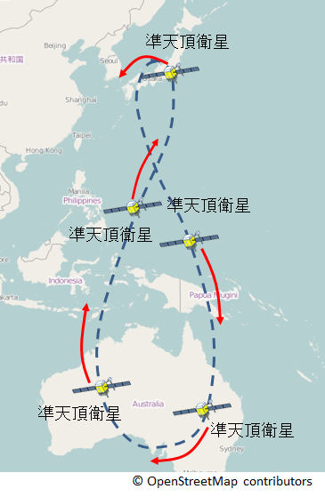
▲ The orbit of Quasi Zenith Satellites System (QZSS)
One of my goals is to bring the simulation results close to the actual measurements, and I do put my resources into this research. However, I understand that it is not as simple as "the more accurate, the better the research". At the end of the day, it is a balance between cost and outcome.
For example, when trying to simulate a moving object such as a running car, it is difficult to perfectly trace the reception environment of the car with respect to its movement. Speaking honestly and clearly, I personally think that it is not necessary to perform that sort of simulation. Instead of tracking the car's movement thoroughly, it is more practical to plot point-by-point along the route, and at each point, know the signal strength and accessibility from the satellite. By doing so, we can find the reception environment of the car at each point and understand the signal strength as well as the degree of positioning error at a certain level. We can expand and apply such knowledge to other areas under similar conditions.
Regarding the accuracy of simulations, I believe that this should be judged either by practicability or by whether it meets the user's demands, and not by consistency with the measured data. You see such types of approaches in other fields. Unfortunately, they are not yet common with regards to GNSS, even at a global level. I feel it is inevitable that we will begin adopting this concept soon.
The idea had been there since the time I was working with Mr. Rei Furukawa of KKE, who was at that time dispatched to ATR (Advanced Telecommunications Research Institute International), and participated in a joint study. As I mentioned earlier, I have a long career involved in GNSS. I also like simulations, ran many simulations related to multipaths, and succeeded in generating results quite close to the actual measurements. It was probably because of this background that I easily managed to use RapLab, which wasn't developed for GNSS applications. In other words, RapLab may not be the best tool for those who are not familiar with simulations. Mr. Furukawa and I used to talk about how we wanted a tool that easily lets everyone run GNSS simulations.
I said earlier that building a city from scratch was tough, but implementing a map isn't as simple as it looks either. When developing a useful simulation tool, you need to use topographical data, create a detailed model, understand the factors that lead to satellite positioning errors, and equip the system with computational analysis capabilities. Packaging all those elements, I believed it was possible to develop a satellite positioning analysis tool. If it is well-made, the user will be able to get the results he needs, even if he doesn't have prior knowledge of GNSS. And I often think to myself that this is what the tool has to be.
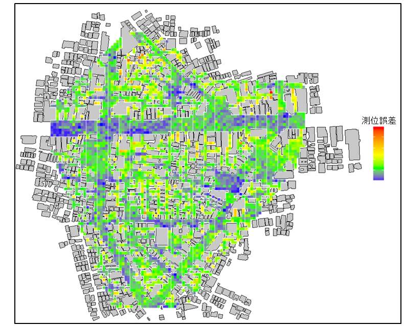
▲ An analysis example of GPS-Studio: GPS/GNSS error map
Currently I am working on research on GNSS, collaborating with people from the nation's research institutes, corporate companies and even universities. When collaborating with such a variety of players, I am often amazed by the unexpected applications for GNSS that are found, such as sports and entertainment. GNSS has become generally known, and there is high potential in it.
On the other hand, as I mentioned earlier, although simulations have reached a point at which they can specify how many satellites can be seen at a certain spot in a certain town, unfortunately, this has not yet been used in product development. GPS-Studio is the only satellite positioning analysis tool in Japan. I believe it is a very powerful tool.
The reason why there isn't much hype about running simulations, I feel, is because not many people are interested in simulations because of their complexity. If a tool that anyone could easily use, like GPS-Studio, became more popular, GNSS-related product development would probably change drastically. With these expectations, I would like to continue working with KKE on this research development.
As of now, we're verifying the simulation data for GNSS radio strengths based on the experiment of driving a car in Tsukishima, Tokyo. It feels that something could be done using GPS-Studio as an extension of such experiments. To find out, we should not only depend on ourselves but also try to collaborate with other universities and institutes as much as possible, including KKE. Above all, I believe that it is necessary to teach all of my knowledge and skills to students before letting them take up the responsibilities of the next generation.
With regards to GPS-Studio, I believe that many companies have the following need: "If there were such a tool, I would want to use it". I would like KKE to appeal to society with the mindset that "there are certain things only simulations can accomplish".
Interviewed in April 2015
Overseas Marketing Dept.
TEL:+81-(0)3-5318-3091
E-mail:i-marketing@kke.co.jp